
The who and how of CLN: a summary of users and use cases
From land trusts and government agencies to students and consultants, the Conservation Lands Network is supporting conservation action across the Bay Area. Since July 2017, more than 1,289 individuals have downloaded CLN data and 225 have registered to generate custom Conservation Portfolio Reports. Users are applying the data in a range of use cases, including “regional conservation planning,” “land trust prioritization,” and “wildlife connectivity and habitat modeling.”
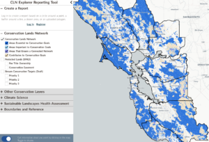
The summary below highlights who is using CLN data and how it is being put to work. Explore the data yourself at bayarealands.org/maps-data or create your own report at bayarealands.org/explorer-tool.
User Types
CLN data is being accessed by a diverse range of users, including:
Academics & Students
- For coursework, research, or thesis projects (e.g., Harvard University, UC Berkeley, Loyola Marymount University, Universidade Federal de Ouro Preto)
- Interests include GIS training, climate adaptation, and habitat modeling
Government Agencies
- For regional planning, environmental review, or transportation-linked conservation (e.g., California Department of Transportation – Caltrans, San Mateo County Parks and Planning)
Nonprofits & NGOs
- For conservation strategy, community planning, and data integration into other tools and planning frameworks (e.g., San Francisco Estuary Institute (SFEI), local land trusts and RCDs)
Private Sector
- For land use planning, trail design, and environmental consulting (e.g., Alta Planning + Design, independent GIS consultants)
- Example use: “SCMSN Trail planning project” or “analyzing ecosystem services”
General Public / Independent Users
- Individuals accessing the data out of personal or professional curiosity or skill development (e.g., “learning GIS,” “research project,” or “interested in ecological restoration” with no listed affiliation)
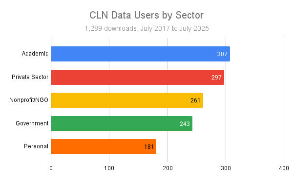
By the Numbers: CLN Data Downloads. The CLN provides data through www.bayarealands.org/maps-data. Before downloading, users complete a brief form requesting their name, email address, affiliation, and intended use of the data. Since July 2017, 1,289 individuals have downloaded CLN data.
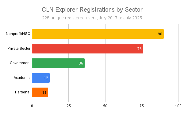
By the Numbers: Explorer Registrations. Users can also generate custom Conservation Portfolio Reports based on CLN data for their specific area of interest using the Explorer tool at www.bayarealands.org/explorer-tool. To run a report, users must register by providing their name and email address. Since July 2017, 225 individuals have registered to use the Explorer Tool.
Common Use Cases
Based on user submissions, the most frequently cited applications of the CLN data include:
- GIS and Mapping Analysis (e.g., “GIS research,” “vegetation rarity modeling,” “applying to my GIS coursework”)
- Trail and Conservation Planning (e.g., “SCMSN Trail planning project,” “open space prioritization,” “community trail network integration”)
- Academic Research (e.g., “research project on land conservation in California,” “climate adaptation modeling for native species”)
- Urban Biodiversity and Stewardship (e.g., “urban wildlife corridors,” “integrating with iNaturalist data,” “planning for native pollinators”)
- Learning and Exploration (e.g., “exploring datasets to build GIS skills,” “student project on conservation strategies”)
Geographic Reach
- Bay Area and California-based users (e.g., Sonoma, Santa Clara, San Mateo Counties; City of Berkeley, City of San Francisco, City of Morgan Hill)
- National and International (e.g., users from Massachusetts, Brazil, and out-of-state U.S. universities)
How will you use the CLN?
Check out our CLN Explorer tool and see what’s possible in your work, studies, or just pure curiosity: www.bayarealands.org/explorer-tool
If you have questions about this tool or the CLN overall, reach out to [email protected].